Category

Aviation

Rural Airport Weather Station

AWOS, ASOS, and Advisory Weather Stations

By Aviation, Blog No Comments

Often a representative of an airstrip will call us asking for an AWOS. This often leads to a discussion of their expectations, needs, and budget.

AWOS vs ASOS

Generic terms often become associated with specific applications, AWOS is one such term. (It is typically pronounced as ay-woss, as in “Hey, toss me that wrench.” Or, “Hey, boss, how about giving me the day off?”)

The full AWOS name (automated weather observation system) sounds generic, but typically implies a class of weather station designated for aviation weather. To confuse things, ASOS (automated surface observing system) is also thrown around in a similar aviation context.

The functional differences are often of minimal importance to the aviation community, but AWOS is typically an FAA-certified weather station under the control of state, local, or private entities. The system is specifically installed and intended for aviation activities.

ASOS equipment is a cooperative effort involving the National Weather Service, FAA, and Department of Defense in the US. Like AWOS, the systems are designed specifically to serve the needs of aviation operations.

Both AWOS and ASOS systems imply a particular set of instruments. AWOS systems can be classified from AWOS I (one) to AWOS IV (four) Z/R. Each system incrementally adds more instruments. AWOS I starts with wind, pressure, temperature, and humidity instruments. Visibility, cloud ceiling, precipitation type, lightning, freezing rain, and runway condition sensors are added with each variant.

Not only is the initial cost of AWOS systems quite high, they must also be maintained by specially trained technicians in order to retain the certification. Due to their complexity and liability, maintenance requires special training anyway. Nevertheless, the total cost is often prohibitive to small airports, fly-in communities, and private operators, even when offset with government grant money.

Small Airports

So, what are small aviation users to do?

Most pilots are familiar with a plethora of aviation tools that run on Apple iPads (which seems to be the brand of choice). These planning and mapping tools often include weather data from AWOS or ASOS sources. Consequently, pilots have an expectation of the range of instrument data these certified systems provide.

However, these iPad tools are often issued under the “Advisory” umbrella, as well as many other instruments that private pilots add to their panel.

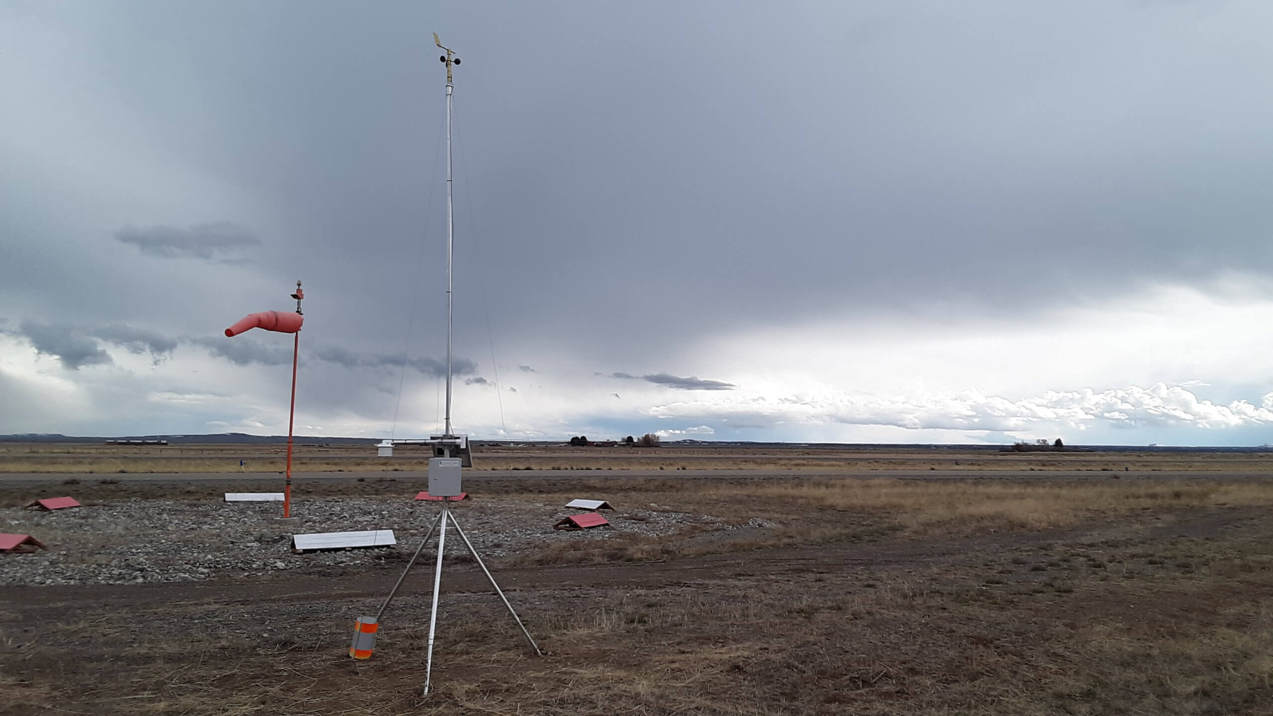
The advisory classification allows community airports, fly-in communities, and clubs to employ weather stations for their users. These could be $50 department store instruments or more expensive equipment like Dyacon MS-130.

The challenge is getting the information that you need, when you need it, and within the budget available.

Features

Dyacon’s weather stations provide a range of capabilities that have the potential to improve aviation safety. First, Dyacon weather stations can be installed, configured, and maintained by local pilots or technicians, no special skills are required. This reduces the total cost of ownership.

Unlike the disposable consumer-grade weather stations, Dyacon stations are modular and repairable.

Aviation weather station SMS text message.

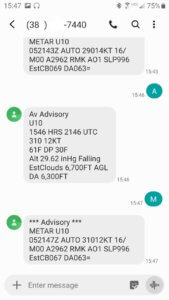
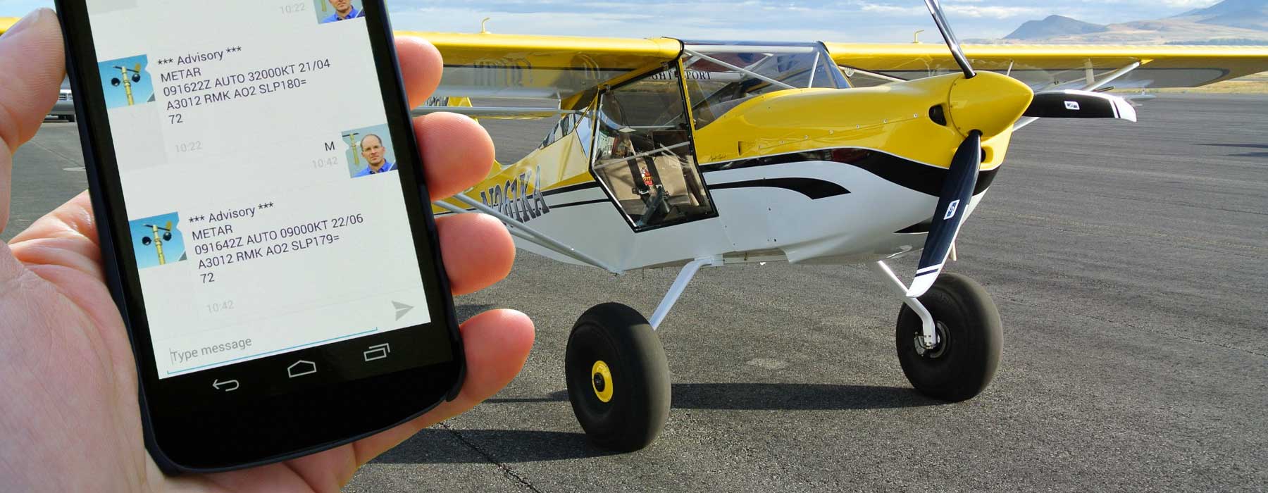
METAR and Plain Language Text Messages

Weather data can be accessed in several ways:

  • SMS text message (METAR and plain-language formats)

  • Web portal (over cell phone)

    Aviation Console for Preston, ID (U10) Weather Station

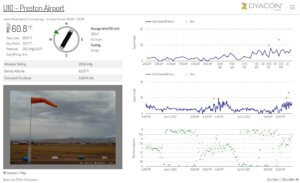
    Aviation Weather Console for Preston, ID (U10)

Both the DyaconLive web portal and SMS text messages provide density altitude, altimeter, and estimated cloud base.

DyaconLive includes both current and historic information as well as NWS forecast information. The charted data helps pilots evaluate on-site weather trends. The web pages are accessible as a simplified public view or can be kept private for specific users.

The DyaconLive aviation console consolidates the critical aviation weather parameters on a single page, which is useful in flight planning rooms for pilots or in waiting areas for guests.

I could going into more features of DyaconLive for system monitoring and maintenance.

If you’d like to know more, give us a call.

Eugene

Flight Weather Data

“Real hit with local pilots”

By Aviation, Blog, Homepage

A Dyacon weather station has been in place at the Preston, Idaho airport for several months. The news of the advisory automatic weather station has been making the rounds among the pilots that use the facility. The weather data is available by SMS text message and WeatherUnderground.

Preston likes to promote their low fuel costs in order to entice pilots to the facility. In July their fuel cost was 100 LL $4.75/gal. This draws a few pilots from the surrounding area.

While preparing to support July’s Sky’s airshow (Facebook), I received the following story:

“So far the weather station has been a real hit with the local pilots and in one case a pilot was able to get the wind speed and direction on a return flight from Driggs, Idaho and made the decision to divert to Bear Lake. Had he pressed on to Preston the situation would have been difficult. That event was on the same day that the family perished on Bear Lake. He landed 30 min before the Bear Lake tragedy.

“Just last week I was able to finally get the phone number to USU, so I am hoping they will use it …, because they had a landing incident that lead to a blown tire and [even with] the cross wind data from the Garmin 1000. I told them that we could look at the actual airport data because of your system… their ears perked up.”

— John Kezele, Preston, ID Airport Board Member

Beat the wind sock. Give us a call for a better solution.

Eugene

Remote Airstrip Crash

By Aviation, Blog

A recent article about a plane crash at a remote airstrip caught my attention:
Hidden Splendor Airstrip Crash

The article states: “A small airplane crashed shortly after takeoff at a remote airstrip in Emery County Saturday afternoon.

“The Emery County Sheriff’s Office said the Cessna 182 airplane was caught in a crosswind which carried the plane off the Hidden Splendor airstrip, clipping one wing and throwing the plane over the edge of a deep wash.” (https://www.ksl.com/?sid=35566853, accessed 21 July 2015)

The following video by utahbyair.com shows several remote airstrips in southern Utah including the location where the above crash occurred.

Small airports may have a wind sock, but most remote airstrips have nothing. In either case, a Dyacon weather station can provide advisory information for a measure of safety and convenience when planning flights.

A simple text message request to a Dyacon weather station provides current conditions in conventional or METAR format. Data is also available through WeatherUnderground, providing current conditions as well as trend information.

Weather stations can be installed by users for permanent or seasonal applications. Dyacon also offers lease options for temporary applications such as short term events or seasonal use.

For wireless services, Dyacon has a direct relationship with Verizon, providing the broadest geographic coverage. This area can be extended by adding a Dyacon directional antenna.

Airshow Weather Station

By Aviation, Blog

Across the country, hundreds of small airports have little or no weather instrumentation. A simple wind sock might be the only indicator of surface conditions, as is the case for the runway in Preston, Idaho.

After nearly a year of preparation in Preston, an airshow was held on August 2, 2014 to raise funds to extend the runway. Prior to the airshow, I noticed that they lacked basic wind instruments, so my beautiful daughter helped me set up an MS-130 weather station near the runway. This station was connected to Weather Underground through the embedded cell phone and also provided SMS text message weather reports.

I would have loved to catch more video of the show, but I could only catch so much because I was sitting with the air boss, receiving quantitative wind data that was relayed to the pilots throughout the event. It was a great experience for me and added a level of sophistication to a small Idaho airport.

Fly safe.

Eugene